Estofex level 2! Nu al waarschuwing voor Zaterdag?
Bericht van: Philippe (Maastricht, Nederland) , 25-07-2013 23:43
Ze zijn vroeg dit keer  Maar 2 dagen van tevoren al een waarschuwing geven... Hmmm.... Ik heb nog nooit een voorwaarschuwing gezien van Estofex, en al helemaal niet met een level 2! Begint toch wel echt spannend te worden nu. Daar gaat mijn barbecue Zaterdagavond....
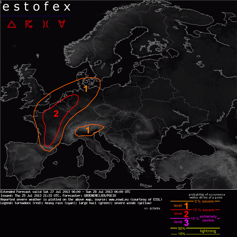
... An outbreak of severe storms is expected across France, the Benelux countries and northwestern Germany...
A level 2 was issued across parts of France, the Benelux countries and northwestern Germany for severe winds and large or very large hail, excessive precipitation and tornadoes.
A level 1 was issued across a larger part of France, the Benelux countries, northwest Germany as well as southeast England, parts of Denmark and north Spain for the same risks.
A level 1 was issued across the southern Alps, mainly for excessive precipitation and large hail.
DISCUSSION...
Saturday, the synoptic situation will be dominated by a strongly amplified trough over the Eastern Atlantic and a ridge that stretches from the Mediterranean towards Central Europe. Between these features, a strong and gradually strengthening south-southwesterly mid- and upper level flow is simulated, with wind speeds between 20 and 35 m/s at 500 hPa level.
The mid-level winds will advect a plume of steep lapse rates off the Spanish Plateau into France, the Benelux Countries and Germany. A corridor of convergent low-level winds and high low-level moisture flanks the western and northern side of the area of steep lapse rates, stretching from southwest France across the southeast Benelux toward north Germany. A pronounced overlap of this low-level moisture and steep mid-level lapse rates should result in CAPE exceeding 1500 J/kg across a large area with pockets up to 3000 J/kg.
A shortwave trough forecast west of the Iberian Peninsula on Saturday morning moves northeastward, reaching central Britain on Sunday morning. In response, a baroclinic wave is expected to develop with pressure falls over central France, and increasing warm air advection over north and west France.
It appears likely that scattered to widespread convection will be ongoing early on Saturday across NW France and the Benelux, probably producing outflow boundaries. New convective storms are simulated to develop along these boundaries during the afternoon, and during the evening in south-central France along the advancing cold front of the wave.
Strong deep-layer shear of 20 - 30 m/s suggests that some storms will become supercells, capable of producing produce large or very large hail.
A southwest to northeast oriented surface warm front is forecast to develop during the afternoon and evening by most NWP guidance, and stretches from north France across the Benelux into northwest Germany. Storm-relative helicity and low-level (0-1 km) wind shear are forecast to be around 200-300 m2/s2 and 10 m/s respectively. Together with relatively low cloud bases, this suggests that some threat of (possibly strong) tornadoes will exist during the late afternoon and evening along and north of the surface front.
Across south-central France, the inflow from the Mediterranean is quite helical too, so that tornadoes cannot be ruled out there either.
It appears likely that individual storms will cluster over time. Some may develop into north-northeastward moving bow echoes producing swaths of damaging winds. Along the cold front that progresses only slowly eastward, subsequent convective cells may train over the same areas, possibly leading to very high rain accumulations and an attendant flash flood risk.
... Alpine region, North Italy ...
Steep lapse rates with abundant low level moisture are expected to yield sizeable CAPE. Moderate vertical wind shear is forecast, decreasing towards east, so that the best storm organisation is expected especially over northeast Italy. Multicells or even brief supercells are forecast, with the threats of large hail and isolated downbursts. In the mountainous areas, slow storm motion might result in local excessive precipitation event.
Maar 2 dagen van tevoren al een waarschuwing geven... Hmmm.... Ik heb nog nooit een voorwaarschuwing gezien van Estofex, en al helemaal niet met een level 2! Begint toch wel echt spannend te worden nu. Daar gaat mijn barbecue Zaterdagavond....... An outbreak of severe storms is expected across France, the Benelux countries and northwestern Germany...
A level 2 was issued across parts of France, the Benelux countries and northwestern Germany for severe winds and large or very large hail, excessive precipitation and tornadoes.
A level 1 was issued across a larger part of France, the Benelux countries, northwest Germany as well as southeast England, parts of Denmark and north Spain for the same risks.
A level 1 was issued across the southern Alps, mainly for excessive precipitation and large hail.
DISCUSSION...
Saturday, the synoptic situation will be dominated by a strongly amplified trough over the Eastern Atlantic and a ridge that stretches from the Mediterranean towards Central Europe. Between these features, a strong and gradually strengthening south-southwesterly mid- and upper level flow is simulated, with wind speeds between 20 and 35 m/s at 500 hPa level.
The mid-level winds will advect a plume of steep lapse rates off the Spanish Plateau into France, the Benelux Countries and Germany. A corridor of convergent low-level winds and high low-level moisture flanks the western and northern side of the area of steep lapse rates, stretching from southwest France across the southeast Benelux toward north Germany. A pronounced overlap of this low-level moisture and steep mid-level lapse rates should result in CAPE exceeding 1500 J/kg across a large area with pockets up to 3000 J/kg.
A shortwave trough forecast west of the Iberian Peninsula on Saturday morning moves northeastward, reaching central Britain on Sunday morning. In response, a baroclinic wave is expected to develop with pressure falls over central France, and increasing warm air advection over north and west France.
It appears likely that scattered to widespread convection will be ongoing early on Saturday across NW France and the Benelux, probably producing outflow boundaries. New convective storms are simulated to develop along these boundaries during the afternoon, and during the evening in south-central France along the advancing cold front of the wave.
Strong deep-layer shear of 20 - 30 m/s suggests that some storms will become supercells, capable of producing produce large or very large hail.
A southwest to northeast oriented surface warm front is forecast to develop during the afternoon and evening by most NWP guidance, and stretches from north France across the Benelux into northwest Germany. Storm-relative helicity and low-level (0-1 km) wind shear are forecast to be around 200-300 m2/s2 and 10 m/s respectively. Together with relatively low cloud bases, this suggests that some threat of (possibly strong) tornadoes will exist during the late afternoon and evening along and north of the surface front.
Across south-central France, the inflow from the Mediterranean is quite helical too, so that tornadoes cannot be ruled out there either.
It appears likely that individual storms will cluster over time. Some may develop into north-northeastward moving bow echoes producing swaths of damaging winds. Along the cold front that progresses only slowly eastward, subsequent convective cells may train over the same areas, possibly leading to very high rain accumulations and an attendant flash flood risk.
... Alpine region, North Italy ...
Steep lapse rates with abundant low level moisture are expected to yield sizeable CAPE. Moderate vertical wind shear is forecast, decreasing towards east, so that the best storm organisation is expected especially over northeast Italy. Multicells or even brief supercells are forecast, with the threats of large hail and isolated downbursts. In the mountainous areas, slow storm motion might result in local excessive precipitation event.
Twitter: @Fliep | 17 jaar en geïnteresseerd in alle weersverschijnselen | Zuid-Limburg, je zal er maar wonen...
 .
.
