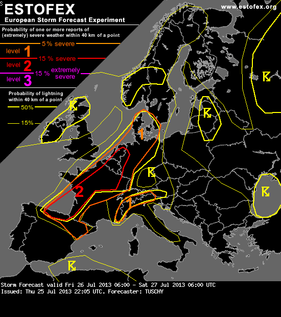
A level 2 was issued for parts of extreme N-Spain, parts of France, Belgium, the Netherlands, Luxembourg and NW Germany mainly for large to very large hail (hail diameter in excess of 5 cm possible), severe to damaging downbursts, excessive and potential flash flood producing rainfall amounts and an isolated tornado event.
A level 1 surrounds the level 2 for a similar hazard but with a low chance for extreme events.
A level 1 was issued for extreme SE-France and far N-Italy mainly for excessive rainfall amounts, isolated large hail and strong to severe wind gusts.
SYNOPSIS
A constant blocking pattern remains in place with strong ridging over S/C-Europe flanked by two stout troughs, one over the far E-Atlantic and the other one over far W-Russia.
At the surface, a quasi-stationary and wavy frontal boundary runs from the SE Bay of Biscay all the way to Denmark. Numerous small-scale disturbances evolve along that boundary and serve as foci for severe DMC. Probably the most pronounced surface pressure fall is expected during the night hours over the SE Bay of Biscay and SW France.
No other synoptic fronts play a role in today's thunderstorm forecast.
DISCUSSION
... NE France, Benelux, parts of Denmark and parts of Germany ...
The big issue with this pattern is the absence of any serious forcing. A short wave over UK and Benelux rotates north until noon and leaves a more or less undisturbed mid/upper level flow regime behind over N-France. Weak mid-level height falls are forecast in all models over N-Germany/Denmark, so initiation there becomes more likely during the latter part of the forecast. For a better overview we split the forecast in certain time-frames:
06 - 18Z:
The aforementioned short-wave probably caused the development of one or two large thunderstorm clusters from the night before, affecting mainly Benelux and W/NW Germany during the morning hours. This activity is probably also tied to a warm front, which crosses the area of interest from SW to NE during that time frame. Diurnal heating on both sides and the departing short wave result in a decelerating and mitigating warm front. Most models show only a temporal weakening trend of thunderstorms during the early morning hours, but rapid re-strengthening is forecast as diabatic heating starts. Forecast data and soundings reveal 500 to 1000 J/kg MLCAPE and 15 to 20 m/s DLS at 9 Z over Benelux with PWs in excess of 40 mm. Ongoing WAA induces also strongly veered profiles, so current thinking is that we will see one or two severe thunderstorm clusters before noon, affecting Benelux and NW-Germany. Those clusters will gradually move offshore around noon. Expect all facets of severe with those storms, including large hail (a first very large hail event already possible), severe wind gusts and flash flood producing excessive rainfall amounts.
In case those clusters either don't evolve or remain smaller than currently anticipated, a more supportive environment will be in place for the next round of DMC.
Timing and extent of the aforementioned clusters determine the strength and position of afternoon convection due to temporarily cooler/stable outflow air behind those storms and limiting heating due to an extensive anvil canopy. The current plan is, that both, rapid air mass recovery behind the storms from forenoon and also scattered development along the synoptic front (W-Benelux) result in another round of severe thunderstorms with the highest coverage of storms probably over the Netherlands and Belgium. Overlap of unseasonably high BL moisture (effective PWs in excess of 40 mm) and moderate mid-level lapse rates offer 1000 to 2000 J/kg MLCAPE build-up within 15 to 20 m/s DLS. Similar shear magnitude is forecast within the lowest 3 km, which raises concerns regarding bowing segments, racing NE-wards along the quasi-stationary synoptic front. Missing forcing limits that risk, but cold-pool driven bowing segments are still very well possible. In that case, expect swaths of strong to severe wind gusts and very heavy rainfall amounts. Despite that risk, limited forcing and strongly veered profiles also support more discrete storms towards NW Germany and well organized multicells and supercells with large to very large hail, severe wind gusts and heavy rain are likely. Despite mainly weak LL shear signals, lowering LCLs during the late afternoon hours (combined with anomalous high BL moisture content), regionally enhanced LL shear especially along outflow boundaries or the synoptic front and expected mature supercell storm mode also points to an isolated tornado risk especially during the evening hours.
A short side-note to the rainfall risk. Despite the progressive nature of the convection, the leisurely NE-ward moving warm front and also the quasi-stationary synoptic front will be the main foci for potential training thunderstorm activity either due to a near normal alignment to the strong background flow (warm-front) or due to repeatedly developing DMC along the wavy frontal system. Flash flooding could become a distinct possibility.
Despite ongoing uncertainties, we upgraded most parts of that area to a level 2 as confidence in numerous severe and a few extremely severe events is high enough.
An high-end level-2 situation however is forecast over NE France during the afternoon and evening hours. GFS and EZ both agree in the development of a plume with very high CAPE on the order of 2000 to 3000 J/kg. Similar shear (speed and directional) is forecast as described above, which is supportive of long-lived and well organized supercells. Current thinking is that either initiation due to a breaking cap (either due to diabatic heating or constant BL moisture increase) or southbound moving outflow boundaries from Belgium result in isolated thunderstorm development over NE-France. Expect explosive development with any cell, which experiences an uncontaminated inflow of very moist and unstable air. Large to very large hail (hail diameter in excess of 5 cm), severe to damaging wind gusts, excessive rainfall amounts and an isolated tornado threat exist with those storms. Despite a SW-erly steering flow regime, deviant storm motion should bring those storms near Paris-Nancy and Luxembourg / S-Belgium.
... 18Z - 06Z ...
The main story probably will be any ongoing supercell over NE France, S-Belgium and Luxembourg, which gradually approaches far W-Germany during the late evening hours. A slow weakening trend should occur with decreasing CAPE and storms also start to outrun strongest shear, but nevertheless, an ongoing risk of supercells/well organized multicells exists over Benelux, NW and W-Germany and NE France until midnight. Large to isolated very large hail, severe wind gusts and locally excessive rainfall amounts are possible next to an isolated tornado event.
A thunderstorm cluster probably affects Denmark during the night as a result of upscale growth of the Benelux activity from the daytime hours. Again, severe wind gusts and heavy rainfall amounts will be the main hazard, but we can't exclude an isolated large hail and tornado event (e.g. with advancing discrete cells).
Models diverge regarding thunderstorm development over C/E-Germany during the night. We think that decreasing mid-level heights should assist in thunderstorm clusters to move more to the E or NE and therefore also affect areas further south (including C/E-Germany). This activity however experiences weaker shear and becomes more elevated in nature, so a decreasing risk is anticipated. Heavy rain, marginal to isolated large hail and gusty winds will be the main risk with 15 m/s DLS and 400 to 800 MUCAPE.
A level 1 surrounds the level 2 for a similar hazard but with a low chance for extreme events.
A level 1 was issued for extreme SE-France and far N-Italy mainly for excessive rainfall amounts, isolated large hail and strong to severe wind gusts.
SYNOPSIS
A constant blocking pattern remains in place with strong ridging over S/C-Europe flanked by two stout troughs, one over the far E-Atlantic and the other one over far W-Russia.
At the surface, a quasi-stationary and wavy frontal boundary runs from the SE Bay of Biscay all the way to Denmark. Numerous small-scale disturbances evolve along that boundary and serve as foci for severe DMC. Probably the most pronounced surface pressure fall is expected during the night hours over the SE Bay of Biscay and SW France.
No other synoptic fronts play a role in today's thunderstorm forecast.
DISCUSSION
... NE France, Benelux, parts of Denmark and parts of Germany ...
The big issue with this pattern is the absence of any serious forcing. A short wave over UK and Benelux rotates north until noon and leaves a more or less undisturbed mid/upper level flow regime behind over N-France. Weak mid-level height falls are forecast in all models over N-Germany/Denmark, so initiation there becomes more likely during the latter part of the forecast. For a better overview we split the forecast in certain time-frames:
06 - 18Z:
The aforementioned short-wave probably caused the development of one or two large thunderstorm clusters from the night before, affecting mainly Benelux and W/NW Germany during the morning hours. This activity is probably also tied to a warm front, which crosses the area of interest from SW to NE during that time frame. Diurnal heating on both sides and the departing short wave result in a decelerating and mitigating warm front. Most models show only a temporal weakening trend of thunderstorms during the early morning hours, but rapid re-strengthening is forecast as diabatic heating starts. Forecast data and soundings reveal 500 to 1000 J/kg MLCAPE and 15 to 20 m/s DLS at 9 Z over Benelux with PWs in excess of 40 mm. Ongoing WAA induces also strongly veered profiles, so current thinking is that we will see one or two severe thunderstorm clusters before noon, affecting Benelux and NW-Germany. Those clusters will gradually move offshore around noon. Expect all facets of severe with those storms, including large hail (a first very large hail event already possible), severe wind gusts and flash flood producing excessive rainfall amounts.
In case those clusters either don't evolve or remain smaller than currently anticipated, a more supportive environment will be in place for the next round of DMC.
Timing and extent of the aforementioned clusters determine the strength and position of afternoon convection due to temporarily cooler/stable outflow air behind those storms and limiting heating due to an extensive anvil canopy. The current plan is, that both, rapid air mass recovery behind the storms from forenoon and also scattered development along the synoptic front (W-Benelux) result in another round of severe thunderstorms with the highest coverage of storms probably over the Netherlands and Belgium. Overlap of unseasonably high BL moisture (effective PWs in excess of 40 mm) and moderate mid-level lapse rates offer 1000 to 2000 J/kg MLCAPE build-up within 15 to 20 m/s DLS. Similar shear magnitude is forecast within the lowest 3 km, which raises concerns regarding bowing segments, racing NE-wards along the quasi-stationary synoptic front. Missing forcing limits that risk, but cold-pool driven bowing segments are still very well possible. In that case, expect swaths of strong to severe wind gusts and very heavy rainfall amounts. Despite that risk, limited forcing and strongly veered profiles also support more discrete storms towards NW Germany and well organized multicells and supercells with large to very large hail, severe wind gusts and heavy rain are likely. Despite mainly weak LL shear signals, lowering LCLs during the late afternoon hours (combined with anomalous high BL moisture content), regionally enhanced LL shear especially along outflow boundaries or the synoptic front and expected mature supercell storm mode also points to an isolated tornado risk especially during the evening hours.
A short side-note to the rainfall risk. Despite the progressive nature of the convection, the leisurely NE-ward moving warm front and also the quasi-stationary synoptic front will be the main foci for potential training thunderstorm activity either due to a near normal alignment to the strong background flow (warm-front) or due to repeatedly developing DMC along the wavy frontal system. Flash flooding could become a distinct possibility.
Despite ongoing uncertainties, we upgraded most parts of that area to a level 2 as confidence in numerous severe and a few extremely severe events is high enough.
An high-end level-2 situation however is forecast over NE France during the afternoon and evening hours. GFS and EZ both agree in the development of a plume with very high CAPE on the order of 2000 to 3000 J/kg. Similar shear (speed and directional) is forecast as described above, which is supportive of long-lived and well organized supercells. Current thinking is that either initiation due to a breaking cap (either due to diabatic heating or constant BL moisture increase) or southbound moving outflow boundaries from Belgium result in isolated thunderstorm development over NE-France. Expect explosive development with any cell, which experiences an uncontaminated inflow of very moist and unstable air. Large to very large hail (hail diameter in excess of 5 cm), severe to damaging wind gusts, excessive rainfall amounts and an isolated tornado threat exist with those storms. Despite a SW-erly steering flow regime, deviant storm motion should bring those storms near Paris-Nancy and Luxembourg / S-Belgium.
... 18Z - 06Z ...
The main story probably will be any ongoing supercell over NE France, S-Belgium and Luxembourg, which gradually approaches far W-Germany during the late evening hours. A slow weakening trend should occur with decreasing CAPE and storms also start to outrun strongest shear, but nevertheless, an ongoing risk of supercells/well organized multicells exists over Benelux, NW and W-Germany and NE France until midnight. Large to isolated very large hail, severe wind gusts and locally excessive rainfall amounts are possible next to an isolated tornado event.
A thunderstorm cluster probably affects Denmark during the night as a result of upscale growth of the Benelux activity from the daytime hours. Again, severe wind gusts and heavy rainfall amounts will be the main hazard, but we can't exclude an isolated large hail and tornado event (e.g. with advancing discrete cells).
Models diverge regarding thunderstorm development over C/E-Germany during the night. We think that decreasing mid-level heights should assist in thunderstorm clusters to move more to the E or NE and therefore also affect areas further south (including C/E-Germany). This activity however experiences weaker shear and becomes more elevated in nature, so a decreasing risk is anticipated. Heavy rain, marginal to isolated large hail and gusty winds will be the main risk with 15 m/s DLS and 400 to 800 MUCAPE.
 .
.
 .
.
