Estofex level 1 voor delen van de Benelux voor morgen
Bericht van: Bram (Oldebroek/Bilthoven) , 09-05-2014 23:47
Het gaat over convectie op het koufront wat morgen overtrekt, behorende bij de volgende depressie.
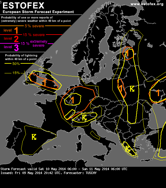
A level 1 was issued for E-France, Belgium, the Netherlands, Luxembourg, NW Switzerland and parts of Germany mainly for severe wind gusts, an isolated large hail risk and an isolated tornado event.
... E-France, Benelux, the Netherlands and Germany ...
A complex forecast ahead. Placement of the mid/upper jets remains unfavorable as its right exit covers eastbound moving cold front over N-France. Some changes occur from noon onwards, as the upper jets drifts a bit to the south and a coupled upper jet configuration evolves along with the right entrance of another jet streak over Germany. Hence, strong upper divergence occurs over Benelux and E-France just as the cold front moves in from the west.
However, a few negative items remain: Upper divergence shifts rapidly E/NE and leaves the front behind during the afternoon hours. Surface front remains anchored beneath the anticyclonically sheared fringe of the mid/upper jets for most the time. Strongest synoptic forcing is displaced to the north (crosses the S-North Sea from W to E), but it also affects that area around noon. Cold front moves into a diffluent regime over Germany during the night with weakening forcing noted in model forecasts. Despite those inhibiting points, we still think a broad level 1 for a forced convective line is needed.
Setup won't favor widespread DMC, but a forced line of mixed shallow/isolated deep convection probably evolves along that cold front. Most probable CI/enhancement of convection is forecast over NE France with peak activity thereafter between S-Belgium, Luxembourg and CNTRL Germany during the afternoon and evening. Dependent on how deep updrafts evolve, either 0-6 km shear in excess of 30 m/s or 0-3 km shear up to 20 m/s both favor organized convection with embedded supercells. An isolated large hail event can't be ruled out, but the main hazard will be strong to severe wind gusts as 25 m/s winds at 850 hPa mix down to the surface. With bowing line segments forecast, concentrated swaths of severe wind gusts are possible. In addition, LLCAPE of 50-100 J/kg, LL speed shear in excess of 15 m/s and SRH-1 of 150 m^2/s^2 and more point to an augmented tornado risk both with more discrete cells but also with embedded (shallow) supercells/bow echoes. We expanded the level 1 to the Netherlands and NW-Germany, where stronger synoptic forcing exists. However concerns exists with approaching dry slot, which could preclude convection. This is reflected in local models. Still, at least a few organized storms can't be ruled out (e.g. along dry slot/front interface).
Both, diminishing forcing and decaying CAPE support a weakening of that convective line over CNTRL Germany, but we would not be surprised if enhanced convection pushes as far east as E-Germany with an ongoing strong to severe wind gust and isolated tornado threat. The southern part of the front drops south/southeast over Germany and becomes aligned more parallel to the background flow. This sometimes causes a breakup of a solid convective line with ongoing weakening but more discrete cells. Strong LL shear and DLS continue to point to an isolated severe wind gust and tornado risk. A similar risk continues over extreme E-France and NW Switzerland. That's why the level 1 was expanded far south.
A level 1 was issued for E-France, Belgium, the Netherlands, Luxembourg, NW Switzerland and parts of Germany mainly for severe wind gusts, an isolated large hail risk and an isolated tornado event.
... E-France, Benelux, the Netherlands and Germany ...
A complex forecast ahead. Placement of the mid/upper jets remains unfavorable as its right exit covers eastbound moving cold front over N-France. Some changes occur from noon onwards, as the upper jets drifts a bit to the south and a coupled upper jet configuration evolves along with the right entrance of another jet streak over Germany. Hence, strong upper divergence occurs over Benelux and E-France just as the cold front moves in from the west.
However, a few negative items remain: Upper divergence shifts rapidly E/NE and leaves the front behind during the afternoon hours. Surface front remains anchored beneath the anticyclonically sheared fringe of the mid/upper jets for most the time. Strongest synoptic forcing is displaced to the north (crosses the S-North Sea from W to E), but it also affects that area around noon. Cold front moves into a diffluent regime over Germany during the night with weakening forcing noted in model forecasts. Despite those inhibiting points, we still think a broad level 1 for a forced convective line is needed.
Setup won't favor widespread DMC, but a forced line of mixed shallow/isolated deep convection probably evolves along that cold front. Most probable CI/enhancement of convection is forecast over NE France with peak activity thereafter between S-Belgium, Luxembourg and CNTRL Germany during the afternoon and evening. Dependent on how deep updrafts evolve, either 0-6 km shear in excess of 30 m/s or 0-3 km shear up to 20 m/s both favor organized convection with embedded supercells. An isolated large hail event can't be ruled out, but the main hazard will be strong to severe wind gusts as 25 m/s winds at 850 hPa mix down to the surface. With bowing line segments forecast, concentrated swaths of severe wind gusts are possible. In addition, LLCAPE of 50-100 J/kg, LL speed shear in excess of 15 m/s and SRH-1 of 150 m^2/s^2 and more point to an augmented tornado risk both with more discrete cells but also with embedded (shallow) supercells/bow echoes. We expanded the level 1 to the Netherlands and NW-Germany, where stronger synoptic forcing exists. However concerns exists with approaching dry slot, which could preclude convection. This is reflected in local models. Still, at least a few organized storms can't be ruled out (e.g. along dry slot/front interface).
Both, diminishing forcing and decaying CAPE support a weakening of that convective line over CNTRL Germany, but we would not be surprised if enhanced convection pushes as far east as E-Germany with an ongoing strong to severe wind gust and isolated tornado threat. The southern part of the front drops south/southeast over Germany and becomes aligned more parallel to the background flow. This sometimes causes a breakup of a solid convective line with ongoing weakening but more discrete cells. Strong LL shear and DLS continue to point to an isolated severe wind gust and tornado risk. A similar risk continues over extreme E-France and NW Switzerland. That's why the level 1 was expanded far south.
Maker van NLradar. Voor de laatste versie (8 augustus 2020) zie: https://www.weerwoord.be/m/2624415
