Ik denk 't niet (Cohen in achterhoofd) Paul graag je reactie
Bericht van: sebastiaan (bussum) , 19-01-2017 17:59
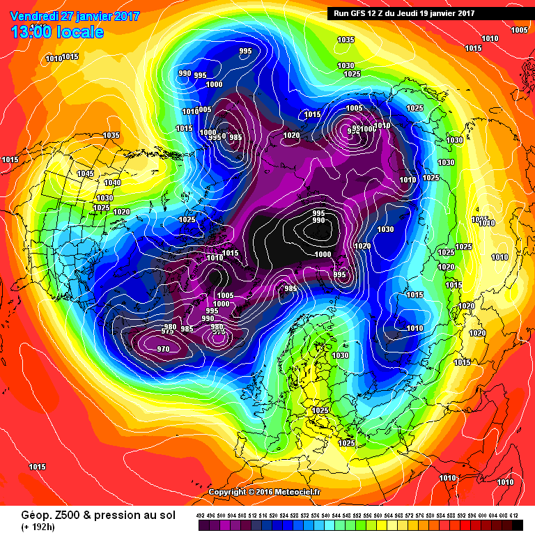
Allereerst. Het is natuurlijk nog ver weg. En we hebben gezien dat Eurohogen veel weerstand kunnen bieden. Maar toch...Toen ik de kaarten zag met een toename van de westelijke stroming moest ik denken aan de opmerkingen van Cohen. Dit gekoppeld aan mijn bijdrage over de forse opwarming in de stratosfeer.
Hij schreef:
The immediate response from the PV weakening will likely be increasing tropospheric ridging/positive geopotential height anomalies over northwestern North America directly under the stratospheric ridge and a deep tropospheric polar low under the displaced stratospheric PV over the north slope of Asia.
Rising heights over Alaska and Northwest Canada will help force troughing/ negative geopotential height anomalies accompanied by a cooling trend downstream over the Eastern US. Counterclockwise circulation around the polar low over the north slope of Siberia will transport North Atlantic maritime air into western Eurasia including Europe resulting in a trend to milder temperatures across the region.
http://www.aer.com/science-research/climate-weather/arctic-oscillation
We zien op 192 en daarna, een sterk hoog bij Alaska en het NW van Canada. Kouder wordende oostelijk deel van de USA.
Milde maritieme lucht zal naar Europa stromen. Hoe ver is natuurlijk de vraag. De SSW (of iets wat in de buurt komt) zou wel eens het einde kunnen betekenen van ons wintertje.
Wat daarna gebeurd is afwachten. Cohen schrijft er over:
However if there are subsequent pulses of WAFz/poleward heat transport this should further weaken the stratospheric PV and nudge it closer to Europe. This could either turn the winds more northerly across Europe or even force the stratospheric PV into Europe. Both of these scenarios would reverse the weather once again across Europe and result in much colder temperatures.
Afwachten dus. Quote selectie
Hij schreef:
The immediate response from the PV weakening will likely be increasing tropospheric ridging/positive geopotential height anomalies over northwestern North America directly under the stratospheric ridge and a deep tropospheric polar low under the displaced stratospheric PV over the north slope of Asia.
Rising heights over Alaska and Northwest Canada will help force troughing/ negative geopotential height anomalies accompanied by a cooling trend downstream over the Eastern US. Counterclockwise circulation around the polar low over the north slope of Siberia will transport North Atlantic maritime air into western Eurasia including Europe resulting in a trend to milder temperatures across the region.
http://www.aer.com/science-research/climate-weather/arctic-oscillation
We zien op 192 en daarna, een sterk hoog bij Alaska en het NW van Canada. Kouder wordende oostelijk deel van de USA.
Milde maritieme lucht zal naar Europa stromen. Hoe ver is natuurlijk de vraag. De SSW (of iets wat in de buurt komt) zou wel eens het einde kunnen betekenen van ons wintertje.
Wat daarna gebeurd is afwachten. Cohen schrijft er over:
However if there are subsequent pulses of WAFz/poleward heat transport this should further weaken the stratospheric PV and nudge it closer to Europe. This could either turn the winds more northerly across Europe or even force the stratospheric PV into Europe. Both of these scenarios would reverse the weather once again across Europe and result in much colder temperatures.
Afwachten dus. Quote selectie
Bericht laatst bijgewerkt: 19-01-2017 18:02
„Et nul ne se connait tant qu'il n'a pas souffert, „C'est une dure loi, mais une loi suprème, „Vieille comme le monde et la fatalité, „Qu'l nous faut du malheur regevoir le baptéme, ~Et qu'a ce triste prix tout doit étre acheté. „Les moissons pour murir out besoin de rosée, „Pour vivre et pour sentir l'homme a besoin de pleura, „La joie a pour symbole une plante brisée, „Humide encore de pluie et couverte de fleurs."

