Slecht weer op komst voor reeds gehavende Bahama's
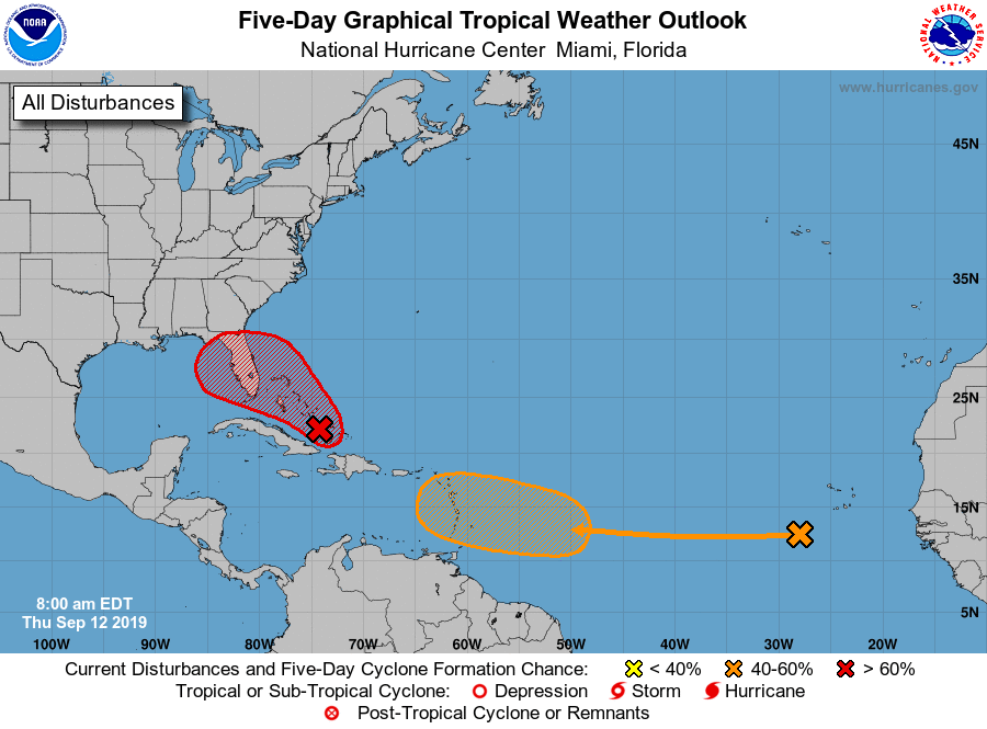
Bericht van: Anthony (Rotterdam) , 12-09-2019 15:25met zelfs mogelijk de formatie van een nieuwe tropische storm boven het noordwestelijk deel van de eilanden. Dit deel is 2 weken geleden getroffen door Dorian. De exacte omvang van de schade en het dodental is daar nog niet eens duidelijk.
Het systeem trekt vervolgens verder richting Florida (hopelijk precies richting Trumps golfresort, daar heb ik minder medelijden mee)
1. Satellite images indicate that the area of disturbed weather over
the central and southeastern Bahamas is gradually becoming better
organized while surface pressures are falling in the area.
Conditions are becoming favorable for a tropical depression or a
tropical storm to form within the next day or so as the system moves
toward the northwest through the northwestern Bahamas and toward
the Florida Peninsula at 5 to 10 mph. If this development trend
continues Potential Tropical Cyclone advisories will likely be
initiated later today. This disturbance will bring heavy rainfall
and gusty winds across portions of the Bahamas through Friday,
especially in portions of the northwestern Bahamas affected by
Hurricane Dorian. An Air Force Reserve reconnaissance aircraft is
scheduled to investigate the system this afternoon, if necessary.
* Formation chance through 48 hours...high...70 percent.
* Formation chance through 5 days...high...80 percent.
Bericht laatst bijgewerkt: 12-09-2019 15:28