Storm Forecast
Valid: Sat 27 Jun 2026 06:00 to Sun 28 Jun 2026 06:00 UTC
Issued: Sat 27 Jun 2026 06:05
Forecaster: PUCIK
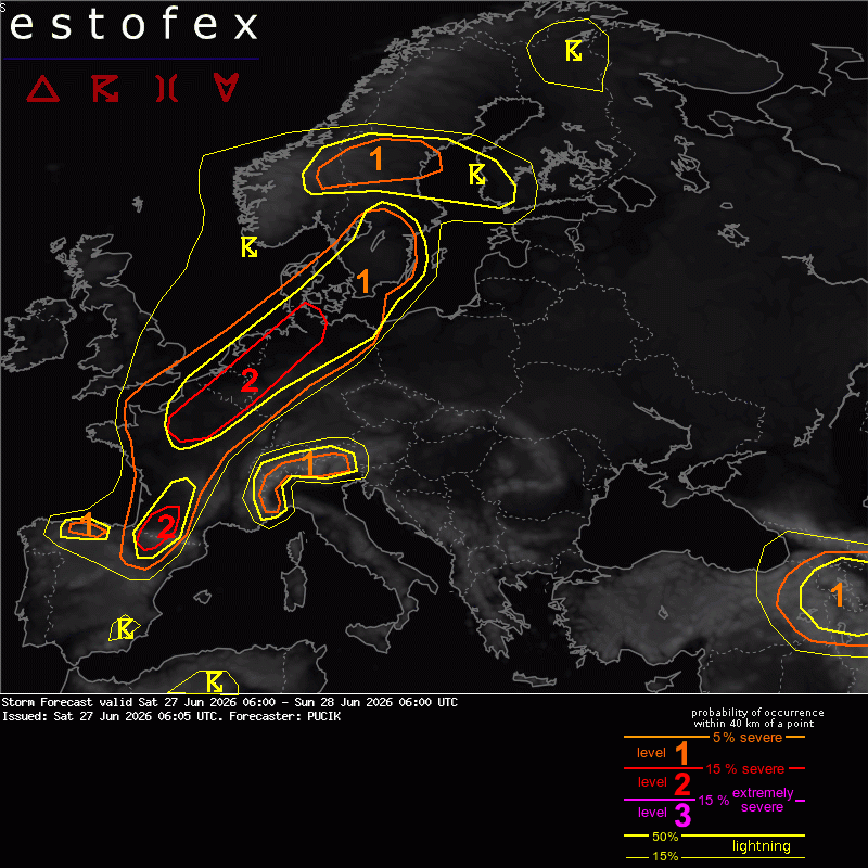
A level 2 was issued from N France through BENELUX into NW Germany mainly for severe and extremely severe wind gusts, as well as large to very large hail.
... France to BENELUX and NW Germany ...
A potential exists for a high-end severe weather outbreak from N France to BENELUX and NW Germany. At the same time, even at the morning of the event, large uncertainty concerning the evolution and coverage of storms exists. Towards 06 UTC, an elevated cluster of storms has formed across extreme NW France, which may affect W Belgium. Some large hail and locally heavy rainfall or marginally severe wind gusts are not ruled out with the more intense storms.
A belt of high MLCAPE values, reaching 2000 to 4000 J/kg will be located west of the dryline boundary separating hot, well-mixed airmass and very warm, moist airmass with specific humidity up to 15 g/kg in the lower troposphere. Fat CAPE profiles with considerable buoyancy above -10 deg C are forecast. Even within the moist airmass, LCLs of 1500 to 2500 m are forecast, lowering towards the evening. Some lingering CIN and dry layers above the LFC are also apparent , especially in the morning to early afternoon hours. With no clear synoptic-scale lift and uncertain evolution of the low-level boundary, precise timing, location and coverage of storms remains difficult to predict. An early morning system may also impact the evolution of the scenario with lingering outflow boundary triggering storms.
Current thinking is that isolated to scattered storms will form over NW Germany and central to N France in the afternoon hours, progressing N/NE into the evening and night hours. A potential for upscale growth into an MCS will exist especially over BENELUX. 0-6 km bulk shear will reach 15 to 25 m/s with mostly straight hodographs, resulting in either splitting supercells or well-organised and long-lived linear segments. Parameter space will favour both large to very large hail and (extremely) severe wind gusts. Some of the high-resolution models indicate long swaths of severe wind gusts that locally exceed 35 m/s. Given the environment, this seems like a plausible scenario. However, even the 00 and 03 UTC model runs do not paint a clear picture in terms of the exact track of the most intense storms, nor their peak intensity. ICON-D2 and RUC suggest that the highest risk could be between 21 and 00 UTC over Netherlands, but probability of severe wind gusts over individual areas remain rather low in the ensembles. Given the limited confidence in terms of the widespread extremely severe wind gust risk, Level 3 was not issued.