Misschien 'ziet' GFS wel als eerste gevolgen van MMW
Bericht van: sebastiaan (bussum) , 20-01-2010 21:26
Ik post vandaag wat berichten van netweather, staan vaak interessante bijdrage op. Ook onderstaande vind ik boeiend.
Referring back to my post 199 with regard to the AO and whether we see a flip back from
the positve mode the models have been showing to a much more blocked and very - AO.
No sooner do I mention this and hey presto, but one run and that being the 06z leaves me
wanting far more proof than this.
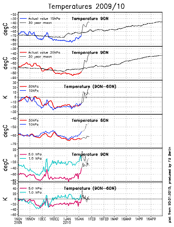
This could very well be the first real signs of the models picking up on the MMW with 30mb
temperatures over the pole and Spitsbergen likely to rise by some 40 degrees over the coming
days if the ECM model is to be believed.
Something to watch and as I said earlier to have such a large change from the 0z run leads me
to think there is more to this than a dodgy 06z run.
Link showing temperatures expected over the Arctic in the coming days at 30mb
+
From t168 onwards and more so by the time we get to t240 it looks dire with a massive vortex
over our side of the Arctic and another over eastern Siberia with admittedly heights to the north
of Alaska.
The GFS was showing the same until this mornings 06z and then 12z run and I am going to speculate and
say that the GFS is the first to pick the pattern change up with a split vortex and blocking to our north and will I hope be looking forward to seeing the ECM come on board in the morning
Referring back to my post 199 with regard to the AO and whether we see a flip back from
the positve mode the models have been showing to a much more blocked and very - AO.
No sooner do I mention this and hey presto, but one run and that being the 06z leaves me
wanting far more proof than this.
This could very well be the first real signs of the models picking up on the MMW with 30mb
temperatures over the pole and Spitsbergen likely to rise by some 40 degrees over the coming
days if the ECM model is to be believed.
Something to watch and as I said earlier to have such a large change from the 0z run leads me
to think there is more to this than a dodgy 06z run.
Link showing temperatures expected over the Arctic in the coming days at 30mb
+
From t168 onwards and more so by the time we get to t240 it looks dire with a massive vortex
over our side of the Arctic and another over eastern Siberia with admittedly heights to the north
of Alaska.
The GFS was showing the same until this mornings 06z and then 12z run and I am going to speculate and
say that the GFS is the first to pick the pattern change up with a split vortex and blocking to our north and will I hope be looking forward to seeing the ECM come on board in the morning
„Et nul ne se connait tant qu'il n'a pas souffert, „C'est une dure loi, mais une loi suprème, „Vieille comme le monde et la fatalité, „Qu'l nous faut du malheur regevoir le baptéme, ~Et qu'a ce triste prix tout doit étre acheté. „Les moissons pour murir out besoin de rosée, „Pour vivre et pour sentir l'homme a besoin de pleura, „La joie a pour symbole une plante brisée, „Humide encore de pluie et couverte de fleurs."