Met office volgt niet hun eigen model. Blijkbaar hebben ze er niet zo veel vertrouwen in.
Headline:
Cold, with wintry showers continuing in exposed parts.
Today:
Cold, with wintry showers continuing to spread to northern, eastern and western parts, especially coasts exposed to the fresh north to northwesterly wind. Showers likely to spread inland across northern Scotland and Northern Ireland. Much drier and brighter inland.
Tonight:
Dry and clear inland, with frost and ice likely in places. Cold, with sleet or snow showers continuing across northern and western parts, especially coasts exposed to the northwesterly wind.
Sunday:
Sleet and snow showers continuing across Northern Ireland, Scotland and western England. A few light showers for southern parts later. Elsewhere dry and bright, but cold, with brisk northwesterly winds.
Updated: 0342 on Sat 30 Jan 2010
Outlook for Monday to Wednesday:
Mostly dry and bright with occasional coastal wintry showers on Monday. Rain, with hill snow, spreading from the northwest on Tuesday. Becoming drier in the north and east on Wednesday.
Updated: 0342 on Sat 30 Jan 2010
UK Outlook for Thursday 4 Feb 2010 to Saturday 13 Feb 2010:
Many eastern areas should be dry at first, although with an increasing risk of wintry showers in coastal areas. Western parts are likely to see outbreaks of rain, becoming heavy at times on upslopes, with a risk of snow in northern Scotland. Temperatures probably near normal in the west but rather cold in the east with overnight frost in places. Wintry showers and clear spells likely over the first weekend of February, with rain likely over low ground in the west but snow more likely elsewhere. Temperatures likely to become cold or rather cold with a widespread overnight frost. The cold conditions are likely to continue throughout the second week of February, with easterly or southeasterly winds bringing cold air from the continent and a further risk of overnight frosts.
http://www.metoffice.com/weather/uk/uk_forecast_alltext.html
Headline:
Cold, with wintry showers continuing in exposed parts.
Today:
Cold, with wintry showers continuing to spread to northern, eastern and western parts, especially coasts exposed to the fresh north to northwesterly wind. Showers likely to spread inland across northern Scotland and Northern Ireland. Much drier and brighter inland.
Tonight:
Dry and clear inland, with frost and ice likely in places. Cold, with sleet or snow showers continuing across northern and western parts, especially coasts exposed to the northwesterly wind.
Sunday:
Sleet and snow showers continuing across Northern Ireland, Scotland and western England. A few light showers for southern parts later. Elsewhere dry and bright, but cold, with brisk northwesterly winds.
Updated: 0342 on Sat 30 Jan 2010
Outlook for Monday to Wednesday:
Mostly dry and bright with occasional coastal wintry showers on Monday. Rain, with hill snow, spreading from the northwest on Tuesday. Becoming drier in the north and east on Wednesday.
Updated: 0342 on Sat 30 Jan 2010
UK Outlook for Thursday 4 Feb 2010 to Saturday 13 Feb 2010:
Many eastern areas should be dry at first, although with an increasing risk of wintry showers in coastal areas. Western parts are likely to see outbreaks of rain, becoming heavy at times on upslopes, with a risk of snow in northern Scotland. Temperatures probably near normal in the west but rather cold in the east with overnight frost in places. Wintry showers and clear spells likely over the first weekend of February, with rain likely over low ground in the west but snow more likely elsewhere. Temperatures likely to become cold or rather cold with a widespread overnight frost. The cold conditions are likely to continue throughout the second week of February, with easterly or southeasterly winds bringing cold air from the continent and a further risk of overnight frosts.
http://www.metoffice.com/weather/uk/uk_forecast_alltext.html
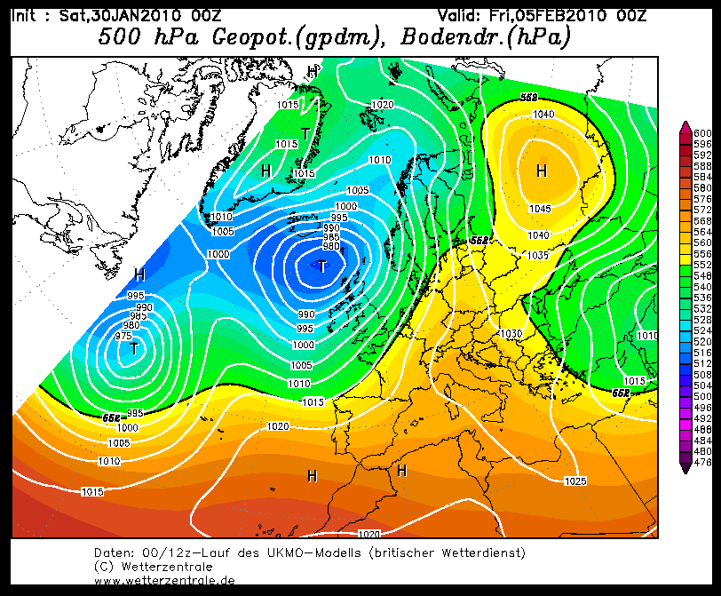
Bericht laatst bijgewerkt: 30-01-2010 13:33
„Et nul ne se connait tant qu'il n'a pas souffert, „C'est une dure loi, mais une loi suprème, „Vieille comme le monde et la fatalité, „Qu'l nous faut du malheur regevoir le baptéme, ~Et qu'a ce triste prix tout doit étre acheté. „Les moissons pour murir out besoin de rosée, „Pour vivre et pour sentir l'homme a besoin de pleura, „La joie a pour symbole une plante brisée, „Humide encore de pluie et couverte de fleurs."