 Kans op downbursts ->
Storm Forecast
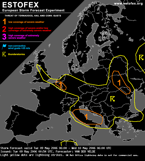
Valid: Tue 09 May 2006 06:00 to Wed 10 May 2006 06:00 UTC
Issued: Tue 09 May 2006 00:54
Forecaster: VAN DER VELDE
SYNOPSIS
A 500 hPa high is situated over southern Scandinavia, with 500 hPa lows over the Ukraine and Italy. A jet at the south side of the Italian upper low and a jet at the west side of the Ukrainean upper low create favorable deep layer shear conditions combined with instability.
The surface flow is such that drier air advects into central Europe from the northeast, while Atlantic cool airmass is advected northeastward. This causes a line of convergence and confluence of the moister air over central Europe into the Benelux and UK.
DISCUSSION
...southern Benelux region...
Compared to the previous day, higher concentrations of boundary layer moisture, of about 6-7 g/kg mixed over the lowest 1000m, will be present according to the GFS model. Part of this is due to advection from northern France and from Poland, ahead of the drier airmass. Consistent precip signals in GFS and NMM over the past few runs and a few hundred J/kg CAPE will allow deep convection. The necessary trigger will mainly be the zone of strong 10m wind convergence in the level 1 area. Outside of this area very localized spots may trigger convection.
The reason for the level 1 is a concern of downburst strength due to evaporational cooling in the dry environment with high LCL heights (around 2000m). In addition to this, models predict an enhanced level of storm-relative helicity with northwestward storm motion, and low-level shear may overlap the CAPE region as well, which may serve to induce updraft rotation. Such cells may be efficient producers of (marginally) large hail, and perhaps a tornado.
...UK...
Narrow line of convergence may trigger some deep convection, probably isolated, which may profit from slightly enhanced storm-relative helicity, with some chance of marginally large hail.
...Italy...
Deep-layer shear maximum of more than 30 m/s over 0-6 km over central Italy may support well-organized cells whose updraft may rotate and generate (marginally) large hail.
...Ukraine into Moldova...
Band of 20-25 m/s 0-6 km shear will wrap around the upper low, when GFS and NMM models create a few hundred J/kg MLCAPE with mixing ratios of only 4-5 g/kg, apparently by steep lapse rates of 7-8 deg/km between 2000-4000m. The upper low may create PVA to trigger the storms, the NMM model also progs a line of convergence at the northeast side of the Carpat mountain chain. If storms indeed form, they may produce (marginally) large hail and (marginally) severe gusts.
...Balkan...
Thunderstorms in stagnant flow will be mainly induced by orographic features, and produce local flash flooding. Landspouts are a real possibility given the steep lower lapse rates and abundant low-level CAPE such as that indicated by 12Z Budapest sounding of the previous day.
...central Europe...
Dry, marginally unstable air may allow very isolated convection with high cloud bases producing strong downburst winds due to evaporational cooling.
Kort stukje uitleg over de zogenaamde "evaporational cooling":
Een onweersbui bestaat uit een updraft en een downdraft. In de updraft wordt warme lucht omhoog getransporteert. Wanneer het LCL (Lifting Condensation Level = de hoogte waarop een pakketje lucht helemaal verzadigd is met waterdamp en dus de hoogte van de wolkenbasis) wordt bereikt ontstaat de wolk. Vervolgens blijft de lucht verder stijgen totdat deze dusdanig is afgekoeld dat de dichtheid te groot wordt.
Wanneer de dichtheid van de lucht groter is dan de dichtheid van de omringende lucht zal ze gaan dalen en ontstaat de downdraft. Wanneer de omringende lucht droog is, zal meer vocht uit de downdraft verdampen, waardoor deze meer afkoeld. ("evaporational cooling")Dit betekent dat de lucht een nog grotere dichtheid krijgt ten opzichte van de omgeving. Hierdoor zal ze alleen maar sneller gaan dalen, wanneer de lucht vervolgens het aardoppervlak bereikt is er sprake van een downburst.
Groeten,
Bas
Bericht laatst bijgewerkt: 09-05-2006 08:46
