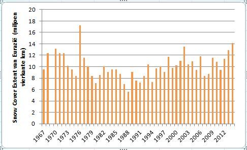
De sneeuwbedekking van Eurazië sinds 1967, het begin van de waarnemingen was op 1976 na de hoogste.
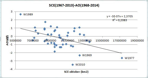
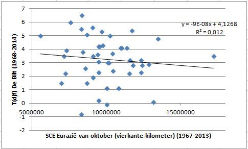
Wat betekent dit voor de winter? Om te beginnen geeft dit een vergrote kans op een negatieve AO (r=-0,45, zie tweede plaatje). Helaas, met de wintertemperaturen van Nederland is de correlatie miniem (zie derde plaatje). Bekend voorbeeld is de winter van 1977, die ondanks een sterke SCE en een negatieve winter-AO toch geen winterweer van betekenis bracht in Nederland.
De SAI heeft een beduidend sterkere correlatie, met zowel de AO als de wintertemperatuur. Over het waarom schrijft Judah Cohen:
'An important unanswered question is why the October SAI is more highly correlated with the DJF AO than the October SCE index. One likely reason is that the SAI is limited to latitudes south of 60°N while the SCE index includes all of Eurasia, which has a significant amount of snow cover north of 60°N. Assuming that the high albedo of snow cover is one if not the most important snow characteristic influencing the overlying atmosphere, this would favour the SAI, which is limited to regions that are exposed to a higher sun angle more so than the SCE, in predicting the atmospheric response to snow cover variability. Another possibility is that the SAI is sensitive to the timing of snowfall, where snowfall at the end of the month contributes to higher values of the SAI and snowfall at the beginning of the month contributes to lower SAI values, while the monthly mean SCE is insensitive to the timing of snowfall.'
(zie link)
Kort gezegd: niet alleen wijkt de SAI af, doordat het een maat is voor de toename van het sneeuwdek, maar ook omdat het een oppervlak betreft dat meer gevoelig is voor veranderingen van de albedo.
In de volgende Weerspiegel (november) gaat Judah Cohen nader in op deze kwestie.
Wat betekent dit voor de winter? Om te beginnen geeft dit een vergrote kans op een negatieve AO (r=-0,45, zie tweede plaatje). Helaas, met de wintertemperaturen van Nederland is de correlatie miniem (zie derde plaatje). Bekend voorbeeld is de winter van 1977, die ondanks een sterke SCE en een negatieve winter-AO toch geen winterweer van betekenis bracht in Nederland.
De SAI heeft een beduidend sterkere correlatie, met zowel de AO als de wintertemperatuur. Over het waarom schrijft Judah Cohen:
'An important unanswered question is why the October SAI is more highly correlated with the DJF AO than the October SCE index. One likely reason is that the SAI is limited to latitudes south of 60°N while the SCE index includes all of Eurasia, which has a significant amount of snow cover north of 60°N. Assuming that the high albedo of snow cover is one if not the most important snow characteristic influencing the overlying atmosphere, this would favour the SAI, which is limited to regions that are exposed to a higher sun angle more so than the SCE, in predicting the atmospheric response to snow cover variability. Another possibility is that the SAI is sensitive to the timing of snowfall, where snowfall at the end of the month contributes to higher values of the SAI and snowfall at the beginning of the month contributes to lower SAI values, while the monthly mean SCE is insensitive to the timing of snowfall.'
(zie link)
Kort gezegd: niet alleen wijkt de SAI af, doordat het een maat is voor de toename van het sneeuwdek, maar ook omdat het een oppervlak betreft dat meer gevoelig is voor veranderingen van de albedo.
In de volgende Weerspiegel (november) gaat Judah Cohen nader in op deze kwestie.